


Marine Vector Maps APP
 ‘GPS Nautical Charts’, the leader in marine & lakes cartography have announced the availability of their updated marine vector maps app for both iOS and Android devices.
You can download and evaluate the software directly from Google Play as well as App Store.
• Google Play link for Marine & Lakes Vector Maps
• Download link for marine & lake vector maps iOS
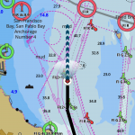
Marine & Lakes coverage
• USA: The US maps includes coverage for entire coast of US, major inland rivers and 7000+ inland lakes. This includes HD contours (1ft / 3ft contour cartography) for popular inland lakes (Lake Barkley, Guntersville Lake, Minnesota Lakes etc.).
• Canada & USA: For those sailing across Canada & US, maps provide a seamless coverage across the border. This also includes coverage of the Trent Severn Waterway and most popular lakes in Ontario.
• Worldwide marine charts coverage: Maps coverage includes coastal waters of several European countries, with more comin
 What’s new in this release?
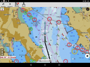
The latest update uses built in GPU to render marine and vector lakes maps. The hardware acceleration allows the app to have high frame rates (60+ fps).
Main features of the new i-Boating client for are:
• Native GPU acceleration: Native GPU rendering is available on all architectures (ARM, Intel & MIPS) – both 32 bit and 64 bit variants
• Rotate maps using gestures
• Text stays upright on rotation.
• Change depth units (ft, metre fathom)
• Seamless maps
• HD contours
• Hybrid renderer
• Route Editing
• Auto Follow
• Track Recording
• Route Assistance with voice prompts
• Tides & Currents


Leave a Reply